
Research Interest
Computer Vision
Image and Video Restoration
Underwater Vision
Segmentation of Aerial Images
Image Memorability
Robotic Vision
Zero Shot Learning
Active Learning
Medical Imaging
Human Gait Analysis
Detection and Rehabilitation for Osteoarthritis
Adversarial Perturbation
Adaptive Video Streaming
Media Forensics
Steganography and Steganalysis
Watermarking and Data Hiding
Satellite Image Processing
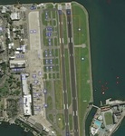
Satellite Image Processing is an important field in research and development and consists of the images of earth and satellites taken by the means of artificial satellites. The satellite imagery is widely used to plan the infrastructures or to monitor the environmental conditions or to detect the responses of upcoming disasters. In MM lab we are focusing on various computer vision applications on aerial and satellite data with Deep Learning. This covers the aerial/satellite semantic segmentation, image translation, super-resolution, colorization, object Detection and tracking.
[1]. Avinash Chouhan, Arijit Sur "ACNet: Aggregated Context Network for Semantic Segmentation of Aerial Images". (Under Review)